
Neil Julian/Alamy
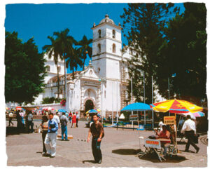
San Miguel Cathedral on Plaza Morazán, the main square of Tegucigalpa, Honduras
From Mayan ruins to modern cities, dense tropical rain forests to majestic mountains, Guatemala and Honduras are a splendid combination of striking geographical features. Look at a map of the two countries to see the varied topography. Where do you see mountain ranges? What are they called? Where do you see lowlands? Locate the capital city of each country. What do you notice about where these cities are located?
Guatemala is the most populated country of Central America. As you can see from on a map of Guatemala, its capital—Guatemala City—and the majority of Guatemala’s other cities and towns are located in the midst of the rugged mountains of south central Guatemala. Just a short distance from the capital city, one can experience the colonial charm of Antigua, the colorful market of Chichicastenango, and the serene beauty of Lake Atitlán. Far from the capital in the remote region of the Petén is the famous Mayan city of Tikal, where a truly fascinating and unforgettable voyage into Guatemala’s past awaits you.
If you were to visit Guatemala, you might expect to hear only Spanish, but it is likely that you would hear at least one of the twenty-one Mayan languages spoken in Guatemala. Some 40 percent of Guatemalans speak a Mayan language as their first language, and indigenous peoples make up about half of the population of Guatemala. In fact, Guatemala has the largest indigenous population in Central America.
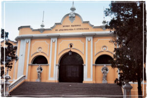
National Museum of Archaeology and Ethnology, Guatemala City, Guatemala
Honduras, like Guatemala, has a rich indigenous heritage. More than 90 percent of Hondurans are mestizos—people with both indigenous and Spanish ancestry. Tegucigalpa, the capital of Honduras, is the home of more than 10 percent of the population.
Honduras is a land of contrasts. The Mosquitia region in the northeast part of Honduras is covered by tropical rain forests and remains almost completely uninhabited. The Río Plátano Biosphere Reserve in this region is the perfect destination for ecotourists. Honduras’ Bay Islands are the home of the second-largest coral reef in the world, and sun-, sand-, and sea-loving visitors flock to these islands. Inhabited by the Maya for nearly one thousand years, Honduras’ Copán ruins are a must-see attraction for those hoping to explore Mayan culture. Follow the link below to view a slideshow about Honduras and Guatemala.
Explore More:
1. The market in Chichicastenango, Guatemala, is quite famous. See what you can find out about this colorful and popular market. What would you like to buy if you went there?
2. Notice the endings of the Guatemalan place names Quetzaltenango, Mazatenango, and Explore the origins of these names and what the suffix –tenango means. Can you find any other cities or towns in Guatemala that end with this suffix?
3. The Toncontín International Airport in Tegcucigalpa, Honduras, is known as one of the most dangerous airports in the world, in terms of take-offs and landings. Research the reasons for this, and try to find some videos of takeoffs or landings at this airport on the Internet. What about the topography of this area contributes to this level of danger?
4. Guatemala and Honduras are neighbors, but what geographical features do they share? Study a map of the two countries to get acquainted with their topography. Based on what you learn from the map, fill in the Venn diagram to compare and contrast the two countries (in Spanish!). Then do some research to learn more about the geography and topography of Guatemala and Honduras. Continue to add information to your Venn diagram. Then discuss what you learned with your classmates.